Direction
Dr. Christophe Sévin (Éveha International)
How Eveha Participates
Archaeological investigations
Location
Sultanate of Oman
Presentation of results
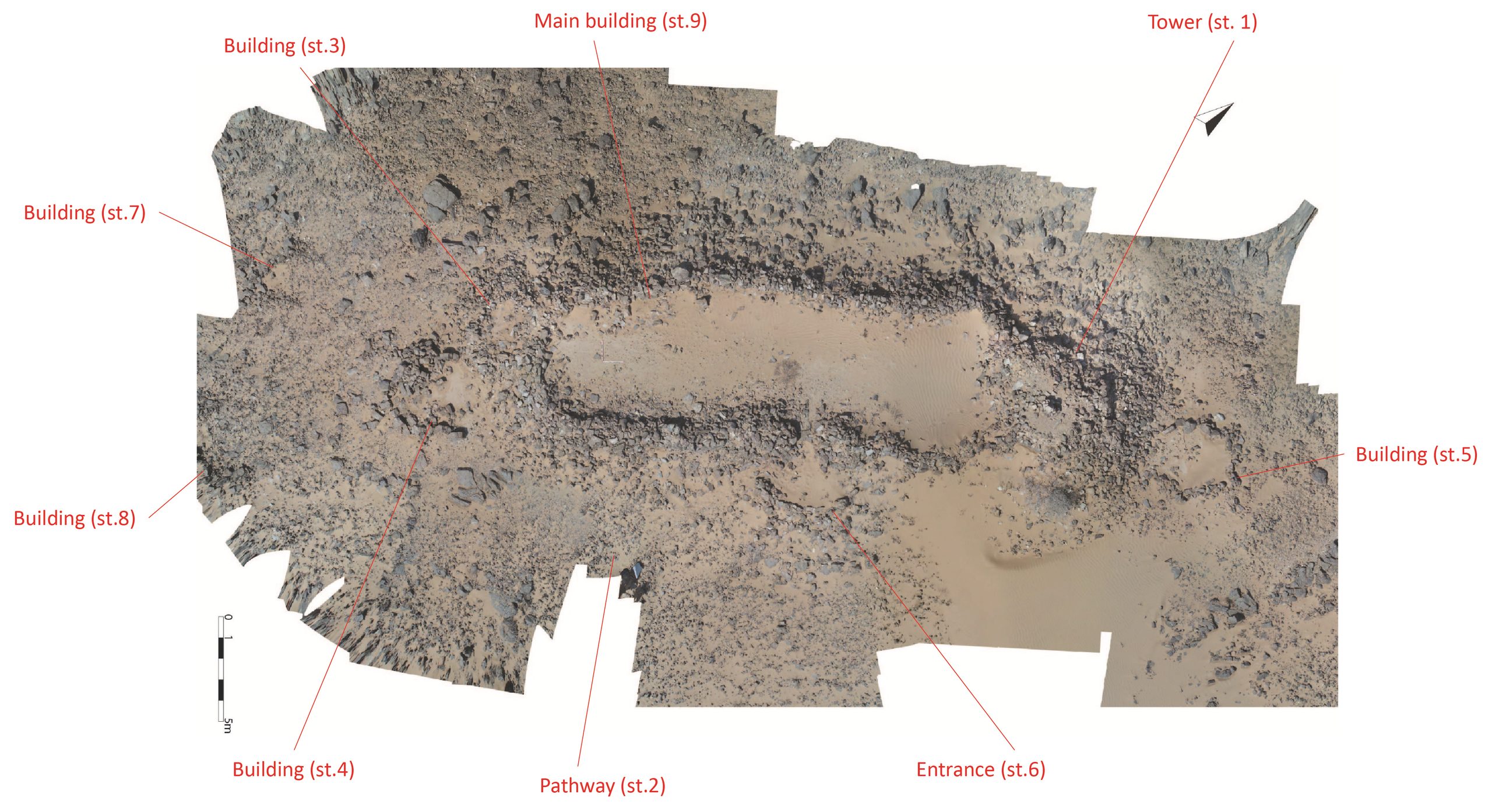
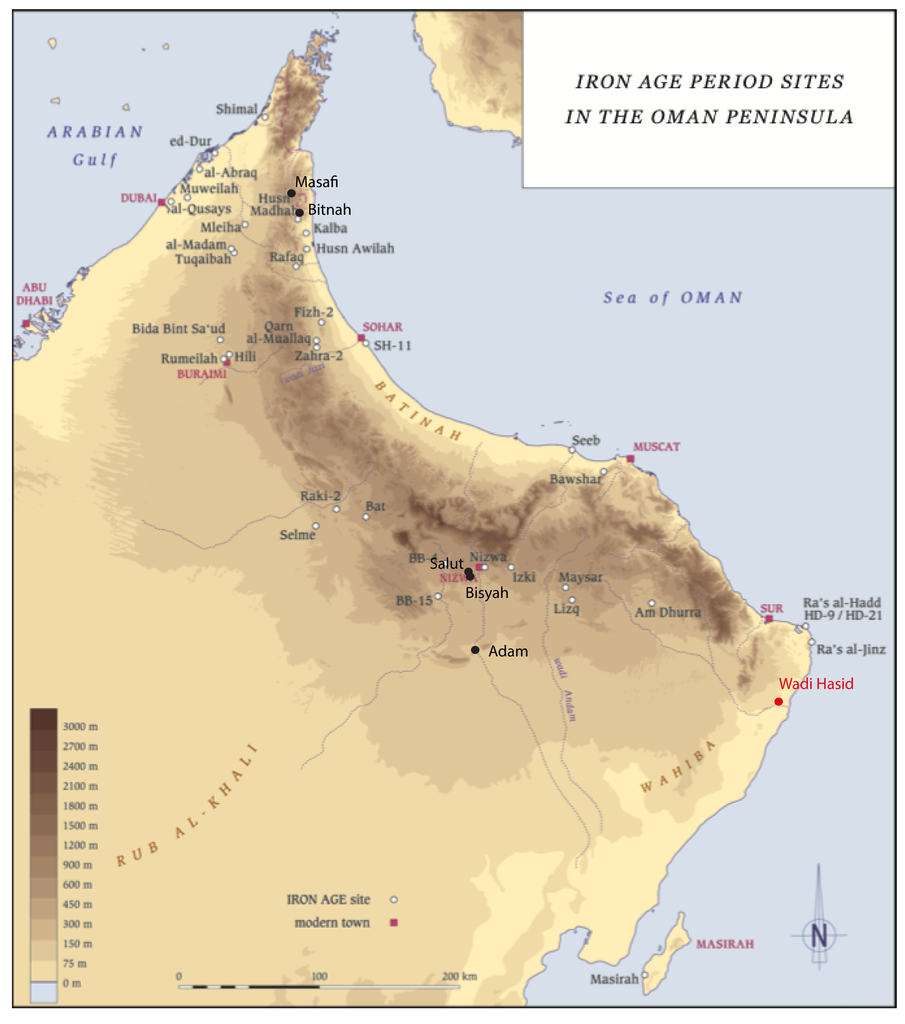
The Wadi Hasid site, located in the Ja’alan region of the Sultanate of Oman, was identified in 2007 during surveys carried out as part of the Joint Hadd Project, directed by Serge Cleuziou and Maurizio Tosi. Positioned at the strategic junction between the coast, the Hajar Mountains, and the Jebel Bani Buali, it occupies a location which, in antiquity, must have facilitated both trade and territorial control. The very first investigations, conducted in 2018 and including photogrammetric surveys and drone imagery, revealed that it is an important hilltop site, the function of which remained to be clarified.
The chronological and cultural framework to which Wadi Hasid belongs corresponds to the first millennium BCE, that is, to the Iron Age in Eastern Arabia (1200–300 BCE). This period was marked by profound social and economic transformations, largely due to the domestication of the dromedary. This new pack animal enabled the development of caravan routes across arid zones that had previously been difficult to access, thus enhancing long-distance overland trade. In parallel, the introduction and refinement of the underground irrigation system — known as qanat in the Middle East and Iran, or falaj in Oman — revitalized oasis agriculture. This technical advance, which flourished especially between 1000 and 600 BCE, offset the agricultural decline caused by climatic aridification from the early second millennium onwards.
In this context, the emergence of fortified hilltop sites, located near water resources, oases, or communication routes, reflects the rise of strong local powers. Such sites — including Lizq and Salut in Oman, and Masafi, Bithna, and Muweilah in the Emirates — reveal tighter control over resources, especially water and mineral resources, with copper being particularly significant. Wadi Hasid shares certain traits with these sites but lies outside their usual geographical distribution, making it a unique case in the archaeological landscape of the peninsula.
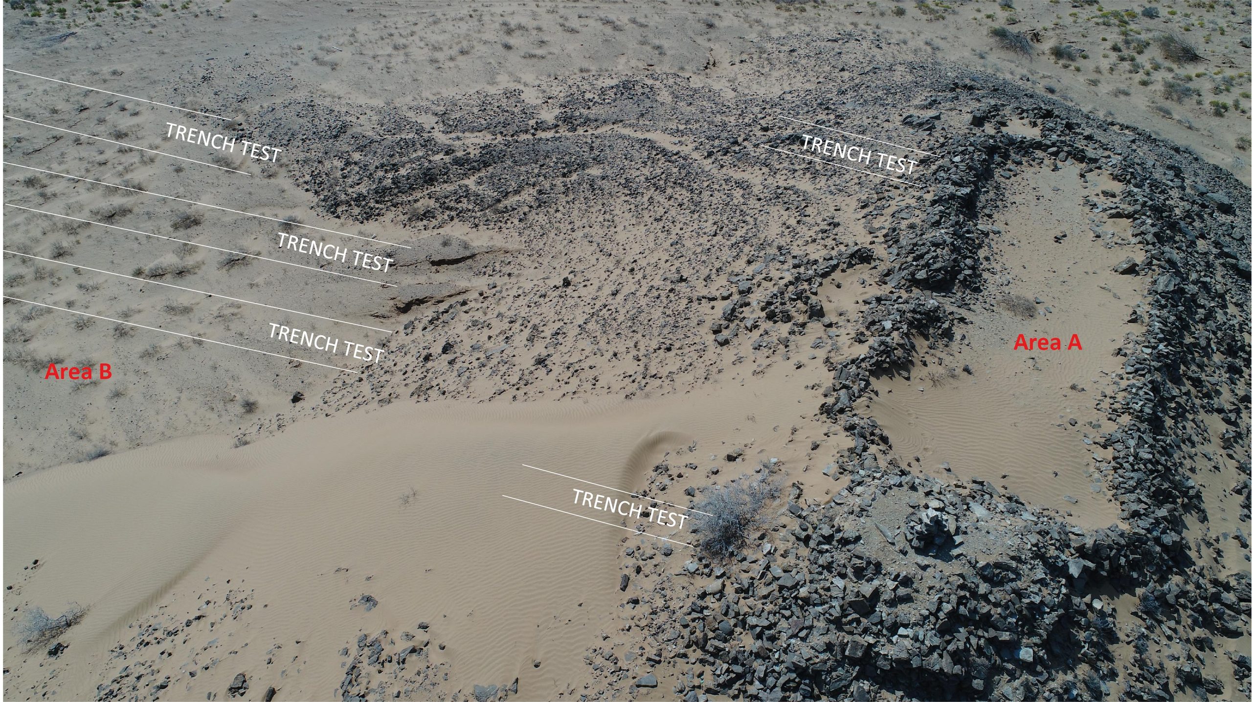
The excavation campaigns conducted in 2024 and 2025 each lasted four weeks and mobilized five full-time archaeologists. The work focused on three main areas: the central monument (Structure 9), the entrance to the adjoining “tower” (Structure 01), and several circular structures located downslope in Area C (it should be noted that the term “tower” is used here with caution, as it is heavily connoted and refers to a very specific style of “Bronze Age monument”; nevertheless, we retain it in quotation marks for lack of a more suitable term to describe this architectural element).
The main monument is an oval building measuring thirty meters in length and six to seven meters in width, located at the highest point of the promontory. To the north, it ends in a “tower” connected by a monumental entrance. The walls, built of dry stone, were likely topped with wooden posts and a vegetal roof. The excavation was organized using a grid of forty squares measuring two meters on a side, twenty-five of which have been explored to date. Each unit was excavated layer by layer, leaving stratigraphic witnesses in certain places. Observations revealed, in most squares, a sequence of natural windblown sand, abandonment layers marked by wall collapses, and, in only a few areas, fragile remains of plaster floors. Artefacts are scarce: a few shells, faunal remains, beads, and musket balls dating to the 17th century, the latter indicating a phase of military or surveillance reoccupation in the modern period. The lack of well-preserved occupation layers in most excavated areas still makes it difficult to interpret the monument’s original function.
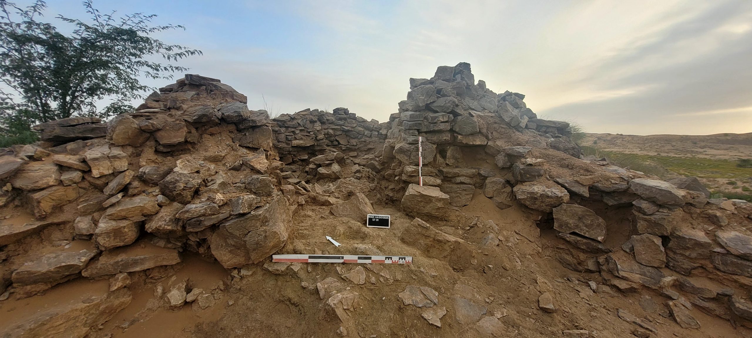
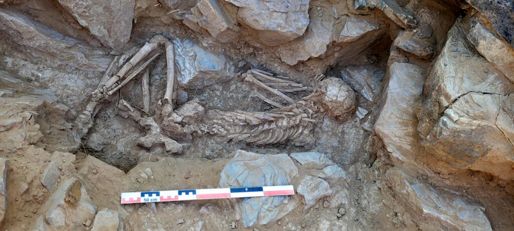
The entrance to the “tower” (ST 01.17) was uncovered in line with the main building during the most recent excavation campaign. Measuring 1.20 m wide and 1.30 m high, it is built of dry stone and features a threshold. In the 7th century CE, during a reoccupation of the site, a funerary deposit was placed inside the “tower,” leading to the blocking of the entrance with collapsed stones. This fill contained human bone fragments from the Iron Age, indicating that the closure disturbed an earlier burial. Indeed, anthropological studies carried out in the “tower” revealed two burials located in its very foundations, beneath its occupation level. The first is that of a young adult aged between seventeen and twenty-two years, buried between 1258 and 1047 BCE, in the Early Iron Age. Laid on the right side, with hyper-flexed limbs and apparently wrapped in a shroud, the individual rested in a quadrangular stone chamber covered by large slabs. Grave goods included carnelian, glass, and shell beads, as well as three copper arrowheads. The second is only partially preserved (lower limbs) and could not be dated for the moment due to calcite contamination of the samples, but its position and depth suggest contemporaneity with the first. The presence of these two individuals in the foundations of the “tower” points to a specific event and intentional act on the part of the community that built the monument, and to the special social status of these individuals. One possible explanation is that they represent foundation deposits, giving these burials particular symbolic significance.
Surrounding this hilltop monument, Area C contains about thirty circular structures identified in 2024. Six were excavated this year. The first (ST 01) is a 1.5 m-wide well built of dry stone, whose fill contained ceramics dating to the Late Iron Age (2nd century BCE–1st century CE). Structures ST 02 and ST 05, dated to the 16th–17th centuries by radiocarbon, feature robust masonry or deep pits filled with stones and may have been used for storage or production during the modern reoccupation. The others (ST 03, ST 04, ST 06) are stone-lined pits or circular constructions, likely for storage or domestic use, some containing Iron Age artefacts. Overall, these results indicate multiple occupations from the Iron Age to the modern period, with functions ranging from water supply to storage.
At this stage, the evidence allows for the identification of four main phases of occupation.
The first, in the Early Iron Age, corresponds to the construction of the monument and the placement of burials in its foundations.
A later phase of use, between the 1st century BCE and the 1st century CE, is attested by the dating of human remains found on the slopes, in one of the cells located there. In the Early Islamic period, between 578 and 654 CE, the “tower” was reused as a funerary space.
Finally, in the modern period, probably in the 16th–17th centuries, the site was reoccupied for military or surveillance purposes, marked by peripheral constructions and the presence of ammunition.
The original function of the Wadi Hasid site thus remains uncertain: defensive outpost, elite residence, ritual center, or a combination of these roles. Future campaigns aim to complete the excavation of the unexplored half of the monument, study the remaining circular structures, trench the slopes to recover discarded material, and extend survey work along the wadi to identify potential associated sites. The site’s strategic location at the crossroads of maritime and overland routes suggests it played a central role in networks of exchange and territorial control for more than two millennia.